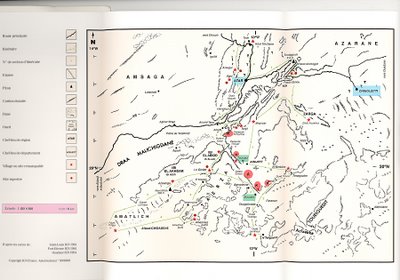
Mauritania: Road map & Milestones
En Français:
Ceci est la carte de notre trek.. scannée
J'ai mis en bleu les 2 villes: Atar (à gauche), ville de départ & d'arrivée du trek, et Chinguetti qui marqua notre "retour à la civilisation", après une longue traversée du desert en 4x4 (environ 4-5 heures)
en vert apparaissent 2 villages que nous avons traversés: Toungad (en haut), et Maaden (en bas) où nous avons visité une école.
les points en rouge sont supposés etre les endroits où nous avons dormi. Il est donc aisé de voir les kilomètres parcourus entre chaque point; quoi qu'il en soit nous avons plus marché que la distance à vol d'oiseau peut laisser entendre. Nous devions marcher pas loin de 15 km par jour !
Nous avons fait le voyage en 4x4 du dernier point rouge (à droite) jusqu'à Chinguetti. On s'est levé comme les autres jours, soit environ 6h30, pour pouvoir partir à la fraiche, et moins souffrir de la chaleur...
vous verrez toutes ces photos plus tard;

In English:
This is the map of our trek.
If you'e noticed, there are colors which mean different things;
In blue, 2 towns, Atar (on the left side) and Chinguetti
Our trek started from Atar and ended by Atar, whereas Chinguetti was our last day between sand and "civilization", after an impressive cruise through hot desert in 4 wheels drive vehicles.
In green, 2 villages, Toungad (on the left) and Maaden where we visited a school.
And in red, 5 points where we were supposed to sleep at night. Within the scale on the left part of the document, you can measure how long (or short) were our daily walks, except it looks shorter on the map than walking in that sand. We were to walk about 15 km each day.
From the last red point (on the right side), we went north and crossed all that territory with 4 WD cars until Chinguetti.
That was an amazing trip as we woke up at 6.30 am, like every day anyway, to leave early and escape from the hot temperatures of mid day...
later on, you will see the pictures of that "cruise" !!!
ciao
back link: click here for Mauritania miles stones
Ceci est la carte de notre trek.. scannée
J'ai mis en bleu les 2 villes: Atar (à gauche), ville de départ & d'arrivée du trek, et Chinguetti qui marqua notre "retour à la civilisation", après une longue traversée du desert en 4x4 (environ 4-5 heures)
en vert apparaissent 2 villages que nous avons traversés: Toungad (en haut), et Maaden (en bas) où nous avons visité une école.
les points en rouge sont supposés etre les endroits où nous avons dormi. Il est donc aisé de voir les kilomètres parcourus entre chaque point; quoi qu'il en soit nous avons plus marché que la distance à vol d'oiseau peut laisser entendre. Nous devions marcher pas loin de 15 km par jour !
Nous avons fait le voyage en 4x4 du dernier point rouge (à droite) jusqu'à Chinguetti. On s'est levé comme les autres jours, soit environ 6h30, pour pouvoir partir à la fraiche, et moins souffrir de la chaleur...
vous verrez toutes ces photos plus tard;

In English:
This is the map of our trek.
If you'e noticed, there are colors which mean different things;
In blue, 2 towns, Atar (on the left side) and Chinguetti
Our trek started from Atar and ended by Atar, whereas Chinguetti was our last day between sand and "civilization", after an impressive cruise through hot desert in 4 wheels drive vehicles.
In green, 2 villages, Toungad (on the left) and Maaden where we visited a school.
And in red, 5 points where we were supposed to sleep at night. Within the scale on the left part of the document, you can measure how long (or short) were our daily walks, except it looks shorter on the map than walking in that sand. We were to walk about 15 km each day.
From the last red point (on the right side), we went north and crossed all that territory with 4 WD cars until Chinguetti.
That was an amazing trip as we woke up at 6.30 am, like every day anyway, to leave early and escape from the hot temperatures of mid day...
later on, you will see the pictures of that "cruise" !!!
ciao
back link: click here for Mauritania miles stones


Comments